I love to hunt for and collect antiques from Vancouver, Washington’s past. The antiques give me a glimpse into Vancouver’s history and provide me with countless subjects to write about. I collect maps and have been searching for a 19th-century map of Vancouver for several years.
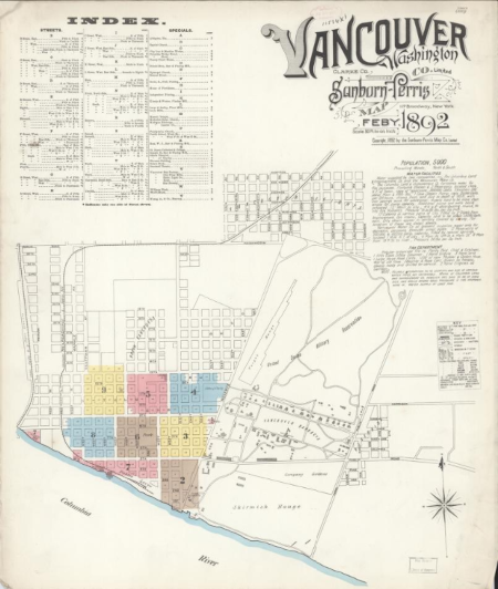
The problem is that these maps, such as this 1892 Sanborn Fire Insurance Map, are very scarce. Although reprints can be purchased online, the only original copies I have been able to locate are in museum collections including the Library of Congress and the Clark County Historical Museum.
Do you have an original map of Vancouver from the 1800s? If so, please call Steve at 503-568-9866!!
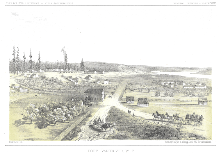
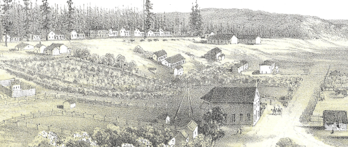
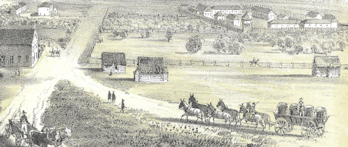
I had to have it when I came across this 1854 lithograph. It’s a bird’s eye view of Fort Vancouver and its surroundings. It’s not a map (I don’t know of any maps of the area from this time frame), but it’s a good representation of what the area looked like at the time.
In the late 19th century, lithography played a significant role in mapping and documenting the exploration and development of the United States. Lithographic printing technology allowed for the production of detailed and accurate maps, illustrations, and documents, making it a valuable tool for explorers, surveyors, and cartographers.
READ: Vancouver and the Great Flood of 1894
About this Lithograph
This lithograph was drawn by Gustav Sohon when he was in the Army working as an artist on the Pacific Railroad Surveys from 1853 to 1855. These exploratory surveys were sponsored by the federal government and were designed to find possible routes for a transcontinental railroad across North America. The lithograph was issued in 1860 in New York by Sarony, Major, & Knapp as part of the USPRR Exploratory and Surveys.
Gustav Sohon, an American artist, interpreter, and topographical assistant, was born in 1825 in Tilsit, Prussia. Sohon immigrated to the United States in 1842 at the age of 17 and joined the Army in the early 1850s. One of his first assignments in the Army was surveying the country between the Rockies and the Bitterroot Mountains for the Pacific Railroad Surveys.
Life in 1854
So, what was life like in Vancouver in 1854 when this lithograph was created?
The Washington Territory had just been created a year earlier when Congress passed a bill establishing the territory on March 2, 1853. The original proposal called for naming the new territory Columbia but that was changed to Washington to avoid confusion with the District of Columbia. In the beginning, before an official county courthouse was built in 1855, county business was conducted in different rented rooms across town with the location changing every couple of months.
The town wasn’t called Vancouver yet. Amos and Esther Short renamed it from Vancouver City to Columbia City in 1850 after they jumped a claim established by American Henry Williamson in 1848. There is a lot of contention around the early establishment of the area west of Fort Vancouver. While most accounts of these events on the internet don’t mention claim jumping, that’s exactly what Amos and Esther Short did.
While Williamson was in California, he left his claim to the supervision of the Hudson Bay Company. But by 1850, The Hudson Bay Company had relocated its North American headquarters to Fort Victoria, Canada leaving behind only a small contingent of employees. With the large influx of settlers into the area due to the Donation Land Claim Act of 1850, I doubt this contingency cared much about looking after Williamson’s claim. As a result, Amos Short, acting as a probate judge in the newly formed Washington Territory, judged that he and Esther were the legal owners of the Williamson land claim.
In 1854, when Gustav Sohon created this lithograph, Columbia City, the town that would become Vancouver, was still in its infancy. While there are no known maps from this period, Sohon’s lithograph gives an accurate visual representation of the area we now know as Vancouver. Whether or not the Short’s claim jumped Henry Williamson’s legal claim, Amos and Esther Short saw the area’s potential and established their homestead here. Over the next several years, the town’s name would change to Vancouver and it would be incorporated by the Washington Territorial Legislature. Vancouver would continue to grow reaching a population of 195,000 in 2024 and becoming the fourth-largest city in Washington State.
"Thank you for reading this article. If you enjoyed it please consider subscribing to my blog. I'll send you an email when I publish a new article. And I will never share your email address and you can unsubscribe anytime."... Steve Carroll
By submitting this form, you are consenting to receive marketing emails from: . You can revoke your consent to receive emails at any time by using the SafeUnsubscribe® link, found at the bottom of every email. Emails are serviced by Constant Contact