

This map of the State of Oregon and the Washington Territory is from the 1859 edition of Colton’s Atlas and represents the year that Oregon became the 33rd state.
The Oregon Territory was established by Congress in 1848 after the Oregon Treaty of 1846 was signed between the United States and Great Britain. The treaty placed the international border between the United States and Great Britain at the 49th parallel. But this didn’t satisfy the settlers in Oregon. They had their eyes on joining the Union as a full-fledged state.
By the 1850s, settlers in the Oregon Territory had grown exceedingly tired of being governed by territorial governors appointed by politicians in Washington D.C.
In 1857, the settlers elected delegates to hold a constitutional convention and write a state constitution, famously without being prompted by the U.S. Congress and prior to being granted statehood. In August 1857, the delegates met in Salem and began preparing a state constitution and making preparations for the transition to statehood. On February 14th, 1859, Oregon was admitted to the Union and became the 33rd State of the Union.
Things of interest on this map
Take a closer look at the map where Vancouver should be and what do you see?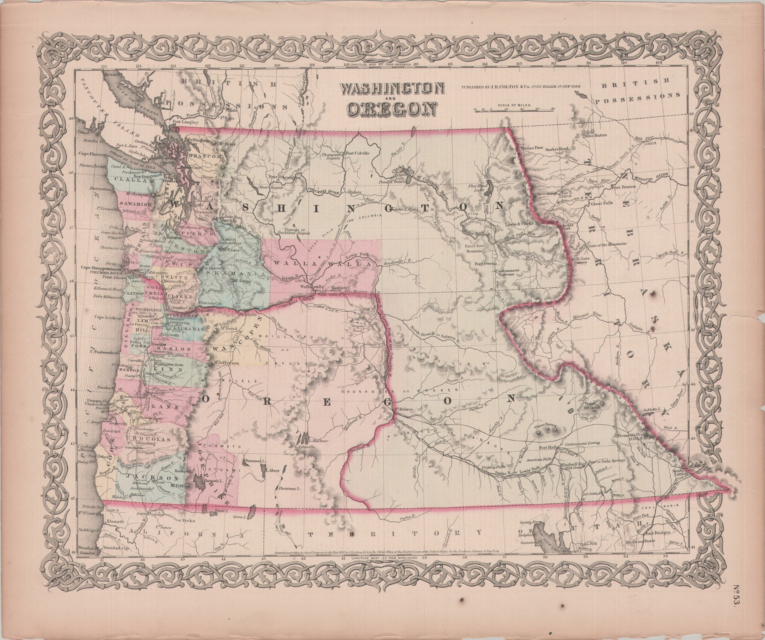
It says Columbia City where Vancouver should be. This is the first time I really noticed this but it doesn’t make sense if this map is in fact from 1859. That is because from 1850 to 1855 this area was called Columbia City. In 1855 the area was renamed to Vancouver so one would think that the above map would say Vancouver and not Columbia City. So the above map, although it was published in 1859, must have been created sometime between 1850 and 1855. In fact, I know that frequently maps back then were re-used in more than one atlas publication. So we have a mystery; what year was this map created? Look at the map up close and find other clues that would narrow down when this map was actually created and then leave your answer in the comments below.
Where can I get a high resolution map of Oregon 1859. I grew up in Lincoln County, attended schools in Siletz and my family were early pioneers of eastern Lincoln County. I would like to incorporate the map into some of my family history.
Hi Rod,
That is very cool! I’ll send you a hi-res copy of the map to your email address when I get home later.
Steve
I am researching the Dolph toll road. Very little information online. My friend owns a homestead that his great grand father acquired in or around 1886. The Dolph road went through his property. There are still sections of the trail and remnants of an old wagon wheel in the creek next to the cabin. I would love to see a map of the entire Dolph road if such exists. My friend grew up down there and remembers the names of all the homesteaders that lived there and where the houses were located. Most of the homesteaders sold out in the 20s and 30s to the lumber companies because of the depression. My friend is the only original owner still there. Or should I say decendant.
Hi Tony,
That’s pretty cool that your friend still owns an original homestead! If I come across any info on Dolph Road I’ll reach out to you.
Steve
This map shows Josephine County east of Jackson County where Klamath County is. That’s got to be an error!
Hi Jerry,
I love a good map mystery so I did a little digging. This map was created between 1850 – 1858 and Klammath County wasn’t established until 1882. Jackson County was established in 1852 and Josephine County in 1856. So I hope that explains the error you found.
Steve Carroll